Recent warnings of snow in Denmark, or at least in the Greater Copenhagen area, have brought sleet, frost and the odd flake, but nothing close to what you would call snowfall.
But that will probably change as we move into the second half of this week, according to TV2 and the national forecaster DMI.
Two more days of warm wind
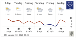
Monday and Tuesday will see a continuation of the recent warm, windy spell, which last week resulted in Denmark’s warmest ever January day. Temperatures will easily exceed 5 degrees on both days.
But the arrival of a low pressure system on Wednesday, which promises to be very wet whatever precipitation there might be, will see temperatures plummet.
Cold air from the north will bring sleet, and then snow and freezing temperatures, which will probably result in the whole country waking up to a blanket of snow on Friday.
Nothing’s 100 percent given Saturday’s forecast
As has been the case with recent forecasts, there is a degree of uncertainty.
For example, while Copenhagen can expect 6 and 3 cm of snow on Thursday and Friday, Saturday will see temperatures soar to 7 degrees before falling again on Sunday.
According to DMI’s provisional forecast, Sunday to Tuesday next week will see sub-zero temperatures both day and night.


