Tuck in your skirts and hold on to your hats, because it looks like it's going to get a tad bit windy over the next few days.
The mild weather that the country has been enjoying looks like it might come to a sudden and windy end early next week.
A low-pressure system is moving in with cool air and gale-force winds that could batter the Danish landscape on Monday and Tuesday.
North Atlantic cold front moving in
The low-pressure system will be amplified by the considerable temperature difference between the cold North Atlantic air and the warmer air in northwest Europe, leading to stormy weather.
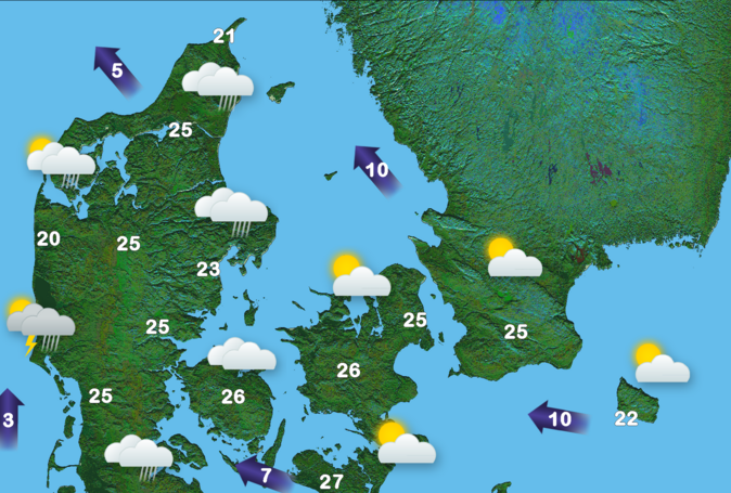
The wind will begin to gather momentum over the weekend reaching speeds of up to 13 metres per second on Saturday and Sunday, before almost doubling to 22 metres per second on Monday.
The national meteorology institute, DMI, has been monitoring the weather in the British Isles for a few days and Steen Rasmussen, a DMI meteorologist, said that Denmark could experience severe weather within the next five days.
“The forecasts are still uncertain about the path of the low-pressure system and its further development, but there is a risk that we will experience strong winds and maybe a storm in parts of Denmark between late Monday and early Tuesday,” Rasmussen said.
Set your clocks back
The temperature will nosedive as well, going from a possible high of 17 degrees over the weekend to just ten by Wednesday.
But on the bright side, we will get an extra hour on Sunday, when we set the clocks back an hour. That will mean Monday morning will be a little less gloomy when we roll out of bed. Of course, that also means that it will soon be dark by 4pm. So there’s that to anticipate.